The fact that it took me 4 days to go through all my pictures says the lot, the trip into the Himalayas was amazing. Mountain vistas in pristine high altitude environment, cyrstal clear rivers, lakes, (n)yaks (and their low altitude relatives), sherpas, villages, massive groups of (mostly Indian and American) trekkers on the highway to Everest Base Camp (EBC), helicopter rescues and the species of the adventurous (?!) 'climber' - the Mt Everest Climber... but more later.
Listening to people before, I was prepared that the main route to EBC would be a single two way highway - up and down and don't stop or look to the left or the right. So this part had to be avoided by any means, hence I looked into the longer so called 'Three Passes Trek' which is described in the Lonely Planet as hard and for the adventurous trekker - well is that me? We'll see. So, I booked a flight to Lukla, bought two walking sticks and some warmer gear and hired a porter/guide to get me over the high passes and as a little insurance to protect my knees after my last 7 knee surgeries. Lets go.
 |
| The route looks promising - ca 150km on the map don't look to bad but don't forget the 10km up and the 10km down. |
 |
| The only way is up (until the last 3 days) - most time is spent just under 5000m height. |
Day 1 Kathmandu (1300m) - Lukla (2800m) - Monjo (2840m): 290m up, 250m down
I admit I almost missed the plane in the early morning. After saying good bye to some traveling companions and closing the last bar the night before, the flight in the 15 seater (?) to Lukla was prommising (not). Lukla, the most dangerous airport in the world, lucky I did not have to fly myself.
The flight seemed never ending and the bumps and holes in the fresh mountain air did the rest - where the hell is the sick bag??? Frantically I searched the seat pocket while searching outside for the landing strips - nothing. Should I opt for my waterproof camera bag? No, not a good idea but at least it wouldn't spill into the plane. Then suddendly relief, there was some form of tarmac and "Bang" - we have set down onto the 15 degree inclined strip. Yes, the landing strip is pointing upwards in order to slow down the plane before it hits the bare rock wall at the end. Out of the plane quick - welcome to Lukla.
 |
| It feels if we are scratching the mountains with the wings... |
 |
| Shortest runway ever - inclined by 15 degree - one attempt only |
The first day is all about getting used to the way of life in the mountains. The main route is like a little highway, just much more pleasant as there are no engines just the bells of the yaks. Porters walk slow(ish) but steady, carry massive and bulky loads up to twice their bodyweight and stop frequently as they walk from dusk till dawn. Tourists walk fast and slow, take pictures at every corner and are out of puff all the time. Yaks and mules are even slower but might push you down the hill if you are not careful. The pointy horns of the yaks are frightening! The sounds of the their bells is relaxing - only broken by the constant 'shhhhh' of the sherpa herding them.
 |
| Head down but strong |
 |
| Truck of the mountains |
 |
| And I was complaining about my backpack... |
 |
Nothing is impossible - try this at home and then
on a little path winding up the mountains |
Day 2 Monjo (2840m) - Namche Bazar (3420m): 600m up
Second day of walking. One big climb of the day with a promising first view of Mt Everest. Well, usually there is a view but today there were some little clouds covering it - so I have to be patient, not my best skill.
But there was another view, an American - a real one better than from any movie:
 |
"Maaan, it sucks here in the mountains -no girls
and no party - time to go back to Bangkok..."
(he told me later that he lived the last 23 years in
Bangkok an has various amounts of women...the knife was real) |
 |
| Awesome little bridges for big loads, animals and trekkers |
 |
| Mind the horns |
Day 3 (1st Acclimatisation Day) Namche Bazar (3420m) - Khumjung (3800m) - Khunde (3820m) - Namche Bazar (3420m): 400m up, 400m down
First day to acclimatise. Goal is to walk high and sleep low. I can feel the height, the breaths getting shorter and the head starts to pound. Welcome to the mountains. After a 5 hour walk I am back in Namche - today there is the famous market where goods being brought to the village. Some goods come straight over a high pass from Tibet while the buffalo is being killed in the valley and being brought up on the back of porters (in pieces). Unfortunately the buffalo doesn't like the altitude and hence doesn't walk himself up to be slaughtered and hence has to be brought up in pieces.
 |
| Market day |
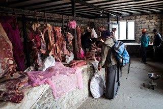 |
| Any meat today? No need for a fridge here as well |
 |
| This fellow has seen the mountains for a while |
 |
| Namche: Every piece of every house has been carried in! |
 |
| Second (not) view of Mt Everest - the arrow points to its approx. location |
Day 4 Namche (3420m) - Tengboche (3867m): 200m down, 650m up
Slowly we are getting up into thin air. The first days are short walking days so that your body gets used to the height and the reduced amount of oxygen. I start to feel every step (up) and the head seems to be especially heavy today (without any drinking!).
Following the path, Mt Everest appears clearly and all is forgotten. We are getting closer. Tengboche is place for one of the biggest monasteries in the area. Good to have some blessing.
 |
| The little one in the centre is Everest, the right one is Lhotse |
 |
| Well deserved rest |
 |
| Dawa in a good mood - as always |
 |
| Some carry more than the others... |
 |
| No discussion of right of way here |
 |
| South face of Everest and Nuptse - nobody on top today |
Day 5 Tengboche (3867m) - Dingboche (4410m): 120m down, 560m up
A perfect morning at 5:30m. The sun is rising and casting a cone of light around Ama Dablam. Does it get any better?
 |
View on Nuptse (7861m), Mt Everest
(8848m), Lhotse (8516m) and the shadow
created by Ama Dablam (6856m) - not a
bad morning |
 |
| Monk's morning wash |
 |
| Ama Dablam towering over |
 |
| We love the morning sun! |
Day 6 (2nd Acclimatisation Day) Dingboche (4410m) - Dingboche Ri (5100m) - Dingboche (4410m): 700m up, 700m down
Summit 1, Dingboche Ri accomplished. First time ever over 5000m - hard work but well worth it. After a 2hr hour slog I finally reach (breathless - not just because of the view) the summit. Wow, the scale is mind blowing - we are so small in the sceme of things. And how on earth could I breath even 3000m higher?
 |
| Morning light |
 |
| Some more morning rays |
 |
| Hairy |
 |
| Sole porter on the way to Lobuche |
 |
| Yaks on the way |
 |
| View from Dingboche Ri (5100m) straight onto Ama Dablam (6856m) - and yes, some people climb this one |
Day 7 Dingboche (4410m) - Chukhung (4730m) - Imja Tsho (5000m) - Chukhung (4730m): 270m down, 590m up
After yesterdays real first high alpine summit I am hooked. Well, I can still feel my legs and head, but again, the only way is up further to Chukhung, an easy 1.5hr walk. On the way we came across the first victim of AMS (Acute Mountain Sickness): a little Korean girl was carried out by a porter towards a helicopter. Her face was as white as it can be and she didn't look good.
So instead of rest - and to avoid AMS - I decided to walk towards the Island Peak Basecamp around which area are some lakes. Did I say that I got a little bit lost and after 2hrs of walking from Chukhung I found myself in the big nowhere? Lucky I left my sherpa in the lodge and he knew where I would (wanted to) go - so he would look for me if I wouldn't have returned in the night...very promising. So be careful and don't break your foot. Bottom line is that I traced my footsteps (thanks to the snow) back and found myself quite happily another further 2hrs later back in the lodge.
Along this area there are amazing views on Island Peak (6189m) which is probably the most climbed so called 'trekking peak' around the area. It is climbed in two days: day 1 is an easy walk into basecamp at around 5100m while day 2 usually is a 14hr slog starting at 2am and which incorporates some iceclimbing and freezing temperatures and then a return to Chukhung at 4730m. Well usually... in my lodge I met some Russian guys whose day 2 turned out to be a 20hr nightmare as they ignored the morning turnaround deadline and kept moving towards the summit. The did not look very happy when they were returning the next night at 10pm to the lodge...idiots.
 |
| No AMS for this one... |
 |
| ...but for this lady carried out by her porter. |
 |
| The right hill is Island Peak (6189m) but where is the path to the lakes? |
Day 8 (3rd Acclimatisation Day) Chukhung (4730m) - Chuckhung Ri (5404m) - Chuckhung (4730): 670m up, 670m down
Summit No 2, am I in summit fever now? After 2.5hrs of steep trek, I reached the summit (south) in the shade of Nuptse and Lhotse. Again, some more amazing views into the valley. How small are we in comparison to the mountains?
 |
| Last steps to the summit |
 |
| Nuptse to the right and the glacier on the left. |
 |
| And there are the lakes which I could not find yesterday... |
 |
View from the top of Chukhung Ri (South - 5404m) towards Nuptse
on the left (7861m). Lhotse and Everest are hidden. |
More in Part II...more images here


Great adventure and great photos - would love to see them on a big screen one day. Despite your low-altitude birthplace it looks like the mountains suit you....must be some alpine DNA somehow, to suck up that thin air so well! More power to you!
ReplyDeletePOH